
How to Fix Discord Error: 'Installation Has Failed'
🕤 11 Jan 2025 Read more

There are numerous apps available on the market, such as Google Maps, Bing Maps, and Apple Maps. Google Maps is the most popular of these, and every cell phone vendor includes it as a standard feature. Google Maps is one of the most useful apps that has become a part of our daily lives and we are using it for free.
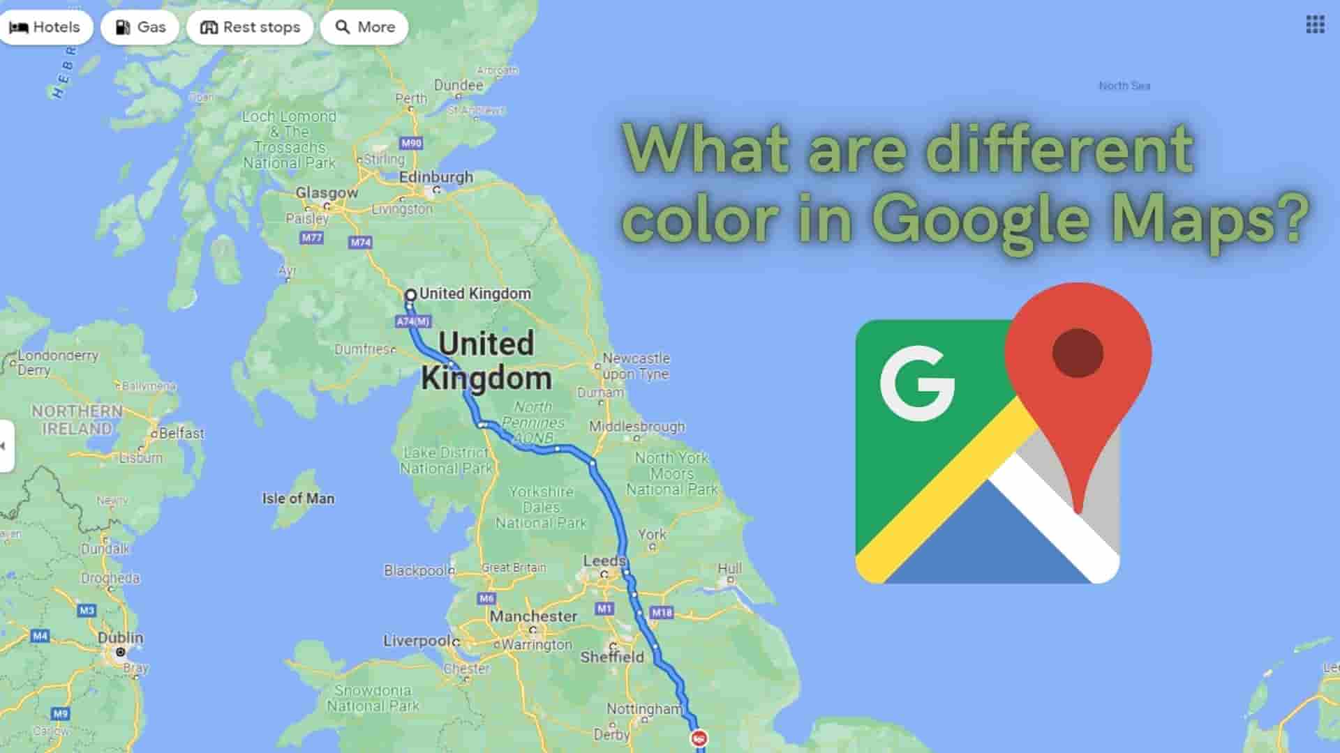
Google Maps suggests the best and alternate routes to the destination. There may be multiple locations to reach the destination, and Google tries to provide multiple possible routes to get there. It also provides live tracking of your path, indicating which paths have a lot of traffic and which do not. Google has used different color stripes to represent the traffic condition on the road in order to know and differentiate different types of paths.
How does Google collect those data?
Actually, when we first use Google Maps, it will ask us to agree to some terms and conditions, which we will accept without reading. In this case, it will say something like "Will access your location." Actually, here Google Maps is asking for permission to access the GPS, which we granted without reading those.
From then on, your phone sends bits of data to the Google server in regular intervals, such as your location, your destination (latitude and longitude coordinates), speeds, and so on. So like you there might be many of us doing this.
As a result, Google Maps will have data from a large number of users and this helps Google to generate accurate real-time traffic conditions which Google Maps represents by various colors, turns directions also provides the best alternative paths. This method of gathering traffic density we call crowdsourcing as lots of information necessary for the crowd is gathered again from the crowd.
And Google Maps has both historical data and live data and results are generated by mixing those results. Google Maps combines all data and generates useful information needed for you with various color lines on the road layer.
Why Google Uses Different Colors?
Google Maps typically provides travelers with an estimate of the road's congestion level, calculated from the current speed and free-flow travel speed, which assists them in better planning their trips and navigating the roads.
Now let's discuss various road colors used in Google Maps.
In general, if you do not have traffic mode enabled in Google Maps, you will only see two color codes on the map, namely white and yellow.
Also you will find :
White Striped : Some airports parking lots are identified by Striped White. It is not applicable to other parking lots in general.
Dark Green Light:The presence of a pedestrian or cycling route is indicated by a dark green light. These routes may be located within a city or within a green area such as a park. Note that it is not green light.
Dark Gray Light: If the dark gray lines are thick, they indicate a road that is undergrown, and if they are thin, they indicate a railroad.
To see other colors in Google Maps let's enable it first.
1 Zoom in the location you are interested in or Search for your location
2 Then Click on the double square shape Layers icon
3 Select desired Map details and Map Type.

Here, I have selected the Traffic label icon under Map details and Default as Map type and then click on the x icon. This will give you traffic maps.
Depending on the traffic situation, you will see different colors on your roads for traffic maps. The most commonly used colors in Google Maps are green, orange, red, and gray. Likewise, different color contrasts indicate clear, moving, slow-moving, or heavily congested traffic.
1 Green Color:(No Traffic)
If you have a green color overlay upon your existing maps then it shows no traffic on the way. There is no congestion on the road and can travel freely on the way.
Green lines on the map indicate that vehicles on the road are moving at a faster rate around 50 miles per hour or more.
2 Orange/Yellow Color: (Moderate Traffic)
If you have an orange color overlay on your existing maps then it shows there is a moderate amount of traffic. Everyone is moving too slow but not stopping. This might be due to road conditions and traffic lights.
Orange lines on the map indicate that traffic is moving at a faster rate, ranging from 25 to 50 miles per hour.
3 Red Color: (High Traffic)
If you have a red color overlay upon your existing maps then it shows there is a high amount of traffic and vehicles are moving very slow or stopped. If it has darker red color then it indicates there is more heavy traffic than the general red color.
The dreaded Red Lines on the map indicates that the traffic is moving at the slowest speed like less than 25 miles per hour or stopped.
4 Dotted Red Color
The dotted Red color in the path indicates the road is color. Along with the path, there will be a stop sign showing the road is closed.
In road signs, a red circle with a white horizontal line means "Do not enter." It might be there is an accident on the way or long-term construction work is going on.
5 Blue Color:(Low traffic/No Traffic)
If you search source and destination and want to travel via vehicles then you will in general see the path with a blue color overlay upon existing maps.
Some light blue color is also used which provides an alternative path to reach the destination. This alternative path may take longer than the previous blue color.
6 Dotted Blue Color
If you choose walking as your mode of transportation, your entire route will be shown as a series of blue dots.
7 Grey Color(Alternative Route)
This path might be guessed from Google. They may represent alternative routes that usually will be longer in distance and/or in time. If you see gray lines, that means there’s no traffic information available at the time.
All information is based on traffic status.
Now let's look at the Map view.
When you open your google map with the default layer you will find these items and color
The process to enable biking trails is shown in the image below.
There is a separate color combination for biking trails and is as follows.
There are various symbols and colors which are used in Google Maps as follows:
Here it shows Food and drinks symbols and colors, retail symbols and colors, outdoor attractions symbols and colors, emergency symbols and colors, city services color and symbols, and traffic incident symbols.
FAQ:
You can create a custom route in Google Maps and send it to your phone. If you have an Android device, you can save it offline.
Yes, Google Maps has a feature called Google Traffic View which allows you to see real-time traffic conditions on your desired location.
This means that currently the road is blocked.
No application gives 100% accurate results. It varies. It can only tell you some things like how long the journey takes on average at the time of day you checked it. It depends on various factors like the speed limit of the road, no. of vehicles right now on the right you are tracking, daytime/ night time, etc.
That it moves at a slower pace. Brown is the worst color, followed by red, which is worse than orange.

.png)